Texas T-4 Pipeline Permits: How Midstream Infrastructure Leads Work
Texas T-4 pipeline permits can become midstream infrastructure leads when matched to route, operator, county, and source context.
By Johnathan · Reviewed by EnergyNetWatch Research · Last updated 2026-05-19
Key Takeaways
- A Texas T-4 permit is a pipeline permit record that can identify operator, county, commodity, classification, and source context.
- EnergyNetWatch matched Civitas T-4 permit 10740 to 15 RRC pipeline route segments, a 4.5-16 inch diameter range, and Foster/Tubb gas gathering system names.
- The Civitas route counties show 115 trailing-12-month drilling permits, 80 reported spuds, and two Civitas Glasscock permits/spuds that create a more specific follow-up package.
Texas T-4 pipeline permits are a different signal from drilling permits. A drilling permit usually points to planned well activity. A T-4 pipeline permit points to pipeline infrastructure: who is operating a line, where it is located, how it is classified, and whether the record can be connected to route context.
That distinction matters for midstream teams, service companies, mineral buyers, analysts, and business-development users. Upstream activity creates the need for gathering, compression, processing, water handling, power, roads, and other field infrastructure. A pipeline permit is one of the public records that can help show where part of that infrastructure story is forming.
A useful T-4 signal is not just the permit number. It is the permit row checked against route data, county activity, nearby wells, recent drilling permits, reported spuds, production history, operator aliases, and related source records.
Texas T-4 Pipeline Permit Example: Civitas 10740
Energy-NetWatch's current Texas midstream project-signal snapshot includes a Civitas Permian Operating, LLC T-4 pipeline permit record that shows why the extra context matters.
| Texas T-4 pipeline permit field | Current EnergyNetWatch signal |
|---|---|
| Source record | Texas RRC T-4 new pipeline permit |
| Permit number | 10740 |
| Operator | Civitas Permian Operating, LLC |
| Operator P-5 | 101577 |
| Commodity | Gas |
| Classification | Private pipeline |
| Counties | Glasscock and Howard, Texas |
| Interstate flag | No |
| RRC new-permits list updated | Apr. 15, 2026 |
| Energy-NetWatch project-signal snapshot | May 19, 2026 |
By itself, that row says the record is a Texas pipeline permit tied to Civitas, gas service, private classification, and two Midland Basin counties.
That is useful, but still incomplete. The stronger signal comes when the T-4 row is connected to pipeline GIS context.
Matched Route Context Makes The T-4 Permit More Useful
For permit 10740, Energy-NetWatch matched the T-4 record to RRC pipeline GIS context.
| Matched route context | EnergyNetWatch signal |
|---|---|
| GIS status | Matched |
| Matched route segments | 15 |
| Diameter range | 4.5-16 inches |
| System names | Foster Gas Gathering; Tubb Gas Gathering |
| Matched counties | Glasscock and Howard |
| Route center | Approx. 32.0623, -101.4725 |
| GIS snapshot | May 12, 2026 |
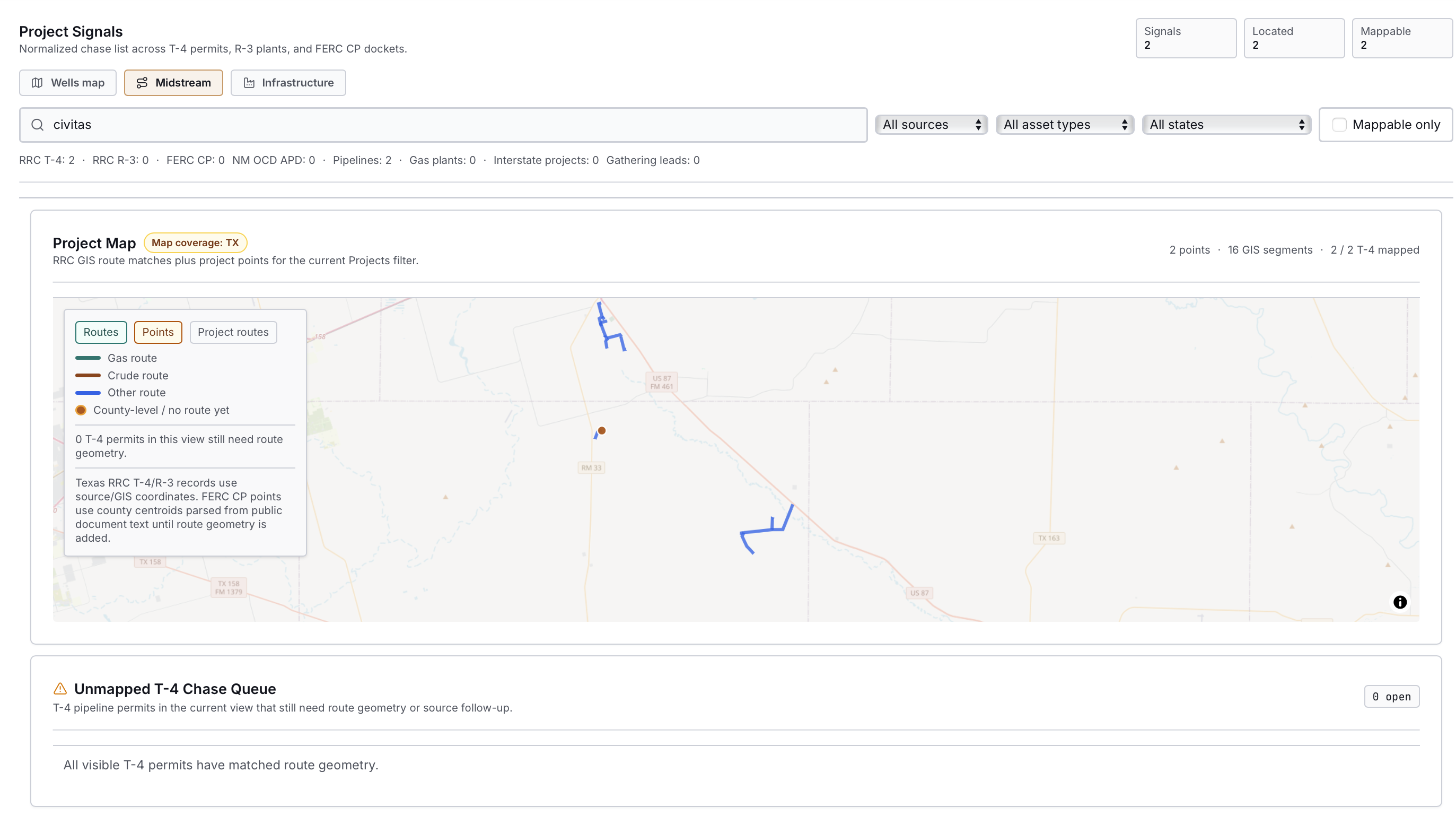
Energy-NetWatch midstream view filtered to Civitas. The map shows route-matched Texas T-4 records and the current chase queue context for the selected project-signal view.
This is the difference between a flat public record and a usable infrastructure lead. The source row identifies a permit. The enriched view adds route evidence, system names, diameter context, counties, operator identity, and a source-confidence signal.
It still does not answer every question. The permit row does not by itself prove in-service timing, project economics, counterparty exposure, or final construction status. It does, however, give a much better starting point for a follow-up workflow.
What A T-4 Pipeline Permit Is
The Railroad Commission of Texas describes T-4 permits as pipeline permit applications used by pipeline operators to register applicable pipelines. The RRC says pipeline permits are required for transmission pipelines, gathering lines, and production or flow lines as defined under the relevant Texas pipeline-permit rule.
The RRC also notes that new pipeline permits or amendments require maps and pipeline attributes, and that reviewed data is added to the public GIS map viewer. In its pipeline permitting FAQ, the RRC says a T-4 permit collects information such as who operates the pipeline, where it is located, how it will be operated, and pipeline characteristics.
For public data users, that means a T-4 record is not the same thing as:
| Not the same as | Why |
|---|---|
| Drilling permit | A drilling permit points to well activity; a T-4 permit points to pipeline infrastructure. |
| Production record | Production records show reported volumes; T-4 records describe pipeline permit context. |
| Tank or facility air permit | T-4 is a pipeline permit source; other facility records live in separate source systems. |
| Full project profile | A T-4 row may need route, filing, lifecycle, attachment, and related-source review before it becomes a complete project profile. |
That is why Energy-NetWatch treats a T-4 row as an infrastructure lead, not a finished project conclusion.
Current Snapshot Scope
Energy-NetWatch's current midstream project-signal snapshot was generated on May 19, 2026. It contains 2,267 source-level infrastructure records across three current public-record families:
| Source family | Current snapshot count | What it contributes |
|---|---|---|
| Texas RRC T-4 pipeline permits | 88 | New Texas pipeline permit rows, operator names, counties, commodity, classification, and T-4 follow-up fields |
| Texas RRC R-3 gas plant records | 524 | Gas plant and processing context where source records are available |
| FERC CP docket signals | 1,655 | Interstate project, storage, compressor, certificate, and federal docket context |
The T-4 detail enrichment used for this brief was generated on May 15, 2026. In that detail pass, 78 of the 88 current Texas T-4 records had a direct route match in loaded RRC pipeline GIS. The Civitas example is one of those matched records.
That matters because not every permit row deserves the same confidence label. A T-4 record with no loaded county route match is still a source row. A T-4 record with matched GIS segments, system names, diameter range, and county confirmation is a stronger lead.
Raw T-4 Row vs Enriched Infrastructure Lead
The public T-4 row is the starting point. It identifies the operator, permit number, county, commodity, classification, and whether the record is interstate or intrastate. That is useful, but it does not always tell a business-development user, analyst, or data team what to do next.
Energy-NetWatch uses the source row as the first layer, then adds route and context fields where the public records support them.
| Layer | Raw public T-4 row | Energy-NetWatch enriched lead |
|---|---|---|
| Identity | Permit number, operator name, P-5 number | Operator identity that can be checked against wells, permits, production, and aliases |
| Geography | County names from the permit list | County context plus route center, route bounds, and matched GIS counties where available |
| Asset type | Commodity and pipeline classification | Commodity, classification, system names, diameter range, and route-segment count |
| Source status | Listed in the new-permits source | Matched, candidate, county not loaded, or no route match in the current enrichment pass |
| Follow-up use | Manual lookup | Sales territory, operator watchlist, county watchlist, map review, and source-document follow-up |
| Limits | No complete project narrative in the row | No claim of in-service status, final construction, commercial volumes, or economics unless source documents support it |
That is the practical difference. A raw row shows that a permit exists. An enriched lead shows where to look, what system name appears in the route context, what pipeline size range is visible, and what still needs confirmation.
Recent Texas T-4 Examples From The Same Snapshot
The Civitas example is not a one-off. The same current T-4 enrichment pass contains other route-matched records that show how the workflow applies across operators, commodities, counties, and infrastructure types.
| Permit | Operator | Counties | Source type | Matched route context | Why it matters |
|---|---|---|---|---|---|
| 10740 | Civitas Permian Operating, LLC | Glasscock, Howard | Gas / private | 15 segments; 4.5-16 in.; Foster Gas Gathering and Tubb Gas Gathering | Midland Basin gas gathering lead tied to two active upstream counties |
| 10748 | Enterprise Products Operating LLC | Martin, Midland | Gas / private | 26 segments; 4.5-16 in.; Nail Ranch | Midstream operator signal in core Permian counties with route evidence |
| 10765 | Diamondback E&P LLC | Midland | Gas / private | 14 segments; 4.5 in.; Buchanan Ranch Residue | Operator-linked infrastructure context that can be checked with Diamondback drilling and well activity |
| 10766 | Plains Pipeline L.P. | Culberson, Loving, Winkler | Liquid / common carrier | 43 segments; 4.5-16 in.; Alpha Gathering | Multi-county liquid infrastructure signal across Delaware Basin counties |
| 10762 | Enbridge (Houston Oil TRM) LLC | Brazoria | Liquid / common carrier | 3 segments; 24-36 in.; EHOT | Gulf Coast liquid infrastructure context, different from upstream gathering leads |
These examples show why the source family supports more than one workflow. A Civitas or Diamondback gas/private record is useful for upstream-adjacent gathering context. A Plains or Enbridge liquid/common-carrier record may be more useful for crude logistics, terminal, or broader infrastructure monitoring.
Connecting The Civitas T-4 Lead To Nearby Activity
A T-4 record becomes more useful when it is checked against nearby upstream activity. For Civitas permit 10740, the route context points to Glasscock and Howard County. Energy-NetWatch can then check those counties against drilling permits, reported spuds, and latest-production rows.
This is county-level follow-up, so the record is best used to prioritize review rather than to assert physical connection for every nearby permit, spud, or producing well.
| Activity layer | Glasscock | Howard | What to check |
|---|---|---|---|
| T-4 lead context | Civitas gas/private; route matched | Civitas gas/private; route matched | 15 matched route segments across the two-county route context |
| Drilling permits, trailing 12 months | 47 | 68 | Development activity is visible in both route counties |
| Reported spuds, trailing 12 months | 51 | 29 | Drilling starts are visible after permit issuance |
| Civitas permits/spuds in the route counties | 2 permits / 2 spuds | 0 / 0 | Civitas follow-up is strongest in Glasscock in this snapshot |
| Wells with latest-production rows | 6,026 | 9,439 | Existing producing inventory gives the route context a field-activity backdrop |
| Latest production month represented | Nov. 2025 | Nov. 2025 | Production context trails current permit and spud records |
The same check surfaces two Civitas drilling records in Glasscock County in the trailing 12-month window:
| Permit | County | Lease | Field | Issue date | Reported spud date | Depth |
|---|---|---|---|---|---|---|
| 912590 | Glasscock | Pickle Rick A | Garden City | Jan. 7, 2026 | Jan. 30, 2026 | 8,400 ft |
| 912591 | Glasscock | Pickle Rick B | Garden City | Jan. 7, 2026 | Jan. 30, 2026 | 8,400 ft |
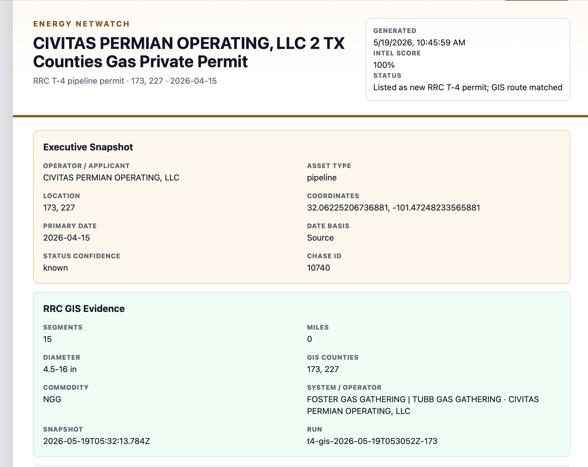
Energy-NetWatch detail view for the Civitas T-4 lead. The record view shows the operator, date basis, coordinates, matched route evidence, diameter range, system names, and source status in one place.
The main signal is that the T-4 permit, route context, two Civitas drilling permits, two reported Civitas spuds, and the broader Glasscock/Howard activity stack create a specific area/operator/county package to review.
That package carries more signal than the permit number alone: Civitas, gas/private T-4, Glasscock/Howard, Foster/Tubb system context, 115 total drilling permits and 80 reported spuds across the two route counties, and production context that currently trails the permit/spud record.
Who Can Use This Signal
The same source record can support different workflows: BD follow-up, route review, infrastructure screening, or API delivery.
| User type | Practical use |
|---|---|
| Midstream business development | Identify operator/county infrastructure leads, then check route context and nearby development before outreach |
| OFS and equipment providers | Watch for gas gathering, compression, measurement, construction, and field-service demand signals |
| Mineral and working-interest buyers | Add infrastructure context to nearby well, permit, and production reviews |
| Analysts | Compare company-reported activity with public-record infrastructure and upstream source signals |
| Data teams | Join T-4 records to permits, wells, production, GIS, and operator identity |
This is why the brief should not be treated as a single-permit story. It is a model for how public infrastructure records become usable when they are joined to the rest of the oil and gas data stack.
What The Public Record Still Does Not Tell You
There are limits. The current public T-4 new-permits list and matched route context do not replace a full project file.
For this example, the missing or follow-up fields include:
| Follow-up field | Why it matters |
|---|---|
| POPS filing date | Helps establish source chronology |
| POPS issue date | Helps confirm permit timing |
| Lifecycle or status history | Helps separate active, amended, transferred, or historical records |
| Application attachments | May provide project narrative or supporting maps |
| In-service date | Needed before treating the record as operational infrastructure |
Those gaps are not a reason to ignore the record. They are a reason to label it correctly. In Energy-NetWatch, this is an infrastructure lead with matched route evidence, not a complete construction or economics report.
Frequently Asked Questions
Is a Texas T-4 permit a drilling permit?
No. A Texas T-4 permit is a pipeline permit record. Drilling permits relate to wells. T-4 records relate to pipeline permitting and mapping.
What does private pipeline mean on a T-4 record?
The classification describes how the pipeline is operated in the source record. In this example, the T-4 record is classified as a private pipeline. That classification should be checked with the source record and, when needed, verified through RRC permit detail.
Why does GIS matching matter?
GIS matching helps turn a permit row into a mapped infrastructure lead. It can add route segments, system names, diameter context, and location evidence that are not obvious from a simple permit list.
Does a matched T-4 record mean the line is in service?
Not by itself. A matched T-4 record means Energy-NetWatch connected the permit row to route context. In-service status, lifecycle history, and supporting documents may require additional source review.
How should teams use T-4 pipeline permit data?
Use T-4 records as infrastructure leads. The strongest workflow connects them to route evidence, nearby wells, drilling permits, reported spuds, production records, facility records, and source-document review.
Related Energy-NetWatch Pages
- Texas drilling permits by operator: May 2026 snapshot
- Diamondback Energy Texas drilling permits: Q1 2026 follow-through
- How to track drilling permits by operator
- Energy-NetWatch methodology
Sources
- Railroad Commission of Texas: New Pipeline Permits
- Railroad Commission of Texas: Pipeline Safety Permitting and Mapping
- Railroad Commission of Texas: Pipeline Permitting and Mapping FAQ
- Railroad Commission of Texas: Public GIS Viewer
- Energy-NetWatch Texas T-4 detail enrichment, generated May 15, 2026.
- Energy-NetWatch midstream project-signal snapshot, generated May 19, 2026.
Data notes
EnergyNetWatch T-4 figures are from Texas RRC public pipeline permit and GIS source records organized in the May 19, 2026 midstream project-signal snapshot. The Civitas example is used as a source-level infrastructure lead with route context, not as a full project profile, construction status, or production forecast.
Recommended next pages
Texas Drilling Permits by Operator: May 2026 Permit and Spud Activity Snapshot
Texas operators ranked by trailing 90-day drilling permits, with recent reported spuds and source freshness notes from EnergyNetWatch.
Diamondback Energy Texas Drilling Permits: Q1 2026 Follow-Through
Diamondback operator intelligence brief covering Texas permit rank, reported-spud follow-through, sample well context, and T-4 infrastructure lead evidence.
How to Track Drilling Permits by Operator Before Production Shows Up (2026)
Learn how to track drilling permits by operator, connect permits to later production signals, and avoid common state-source mistakes.
Texas Oil and Gas Production Data: RRC Records, Wells & Operators
Understand Texas RRC oil and gas production data by well, operator, county, source month, reporting lag, and current EnergyNetWatch table access.
Related EnergyNetWatch pages
Want the current T-4 or PS-48 sample report?
Public articles use selected examples. Request the current signal report if your team needs the current rows, source dates, T-4 status, county/operator rollups, companion CSV, and verification notes.