Midland County Texas Drilling Activity: June 2026 Permit Signal
Midland County Texas drilling activity review using the current June 2026 W-1 permit pull, county rank, operator concentration, source-stage caveats, and EnergyNetWatch workflow context.
By Johnathan · Reviewed by EnergyNetWatch Research · Last updated 2026-06-30
Living operator brief
This page is maintained as an operator intelligence brief, with refreshed permits, spuds, production windows, counties, source labels, and watch items where available.
Key Takeaways
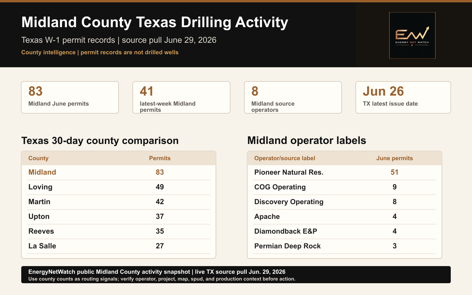
- The current Texas permit table shows a latest issue date of June 26, 2026 and a latest load date of June 29, 2026.
- Midland County leads the current 30-day Texas county permit window with 83 records, ahead of Loving, Martin, Upton, and Reeves.
- The public county page treats permits as drilling-intent records and points to the current county table, map, exports, alerts, and API workflow.
Midland County led the current Texas county permit window in the EnergyNetWatch June 29 source review.
The current Texas W-1 permit table shows a latest permit issue date of June 26, 2026. The latest loaded source date in this review is June 29, 2026.
That puts Midland County on the first screen for Texas drilling-intent activity.
Midland County Texas Drilling Activity Snapshot
In the current June review, Midland County shows 83 Texas W-1 permit records from June 2 through June 26, 2026.
Midland also leads the latest reviewed 30-day Texas county window. Loving, Martin, Upton, and Reeves follow on the same date basis.
| Metric | Current signal |
|---|---|
| Midland County June permits through June 26 | 83 |
| Midland County latest-week permits | 41 |
| Midland County source operators in June window | 8 |
| Texas latest permit issue date | June 26, 2026 |
| Texas permit table loaded | June 29, 2026 |
| Texas latest issue-week permits | 178 |
| Texas latest 30-day permits | 709 |
| Texas June-to-date permits | 708 |
EnergyNetWatch Midland County public activity snapshot from the June 29 Texas source pull. Permit records are drilling-intent signals, not drilled wells.
Permit records are the first activity marker. Drilling, completion, and production evidence come later in the source chain.
For Midland County, the current signal is not just the total. The concentration is visible in the operator labels.
Current Midland Operator Signal
Pioneer Natural Res. USA, Inc. carries most of the current Midland County permit count in this pull. COG Operating, Discovery Operating, Apache, Diamondback, Ovintiv, Permian Deep Rock, and OXYROCK also appear in the county window.
| Operator/source label | June permits | Latest permit date |
|---|---|---|
| Pioneer Natural Res. USA, Inc. | 51 | June 26, 2026 |
| COG Operating LLC | 9 | June 22, 2026 |
| Discovery Operating, Inc. | 8 | June 18, 2026 |
| Apache Corporation | 4 | June 26, 2026 |
| Diamondback E&P LLC | 4 | June 3, 2026 |
| Ovintiv USA Inc. | 3 | June 15, 2026 |
| Permian Deep Rock Oil Co., LLC | 3 | June 24, 2026 |
| OXYROCK Operating, LLC | 1 | June 4, 2026 |
Notable Midland County Rows From This Pull
These examples are a small proof set from the reviewed Midland County table, not the full export.
| Operator/source label | Lease / well | Permit date | Field / profile | Why it matters |
|---|---|---|---|---|
| Pioneer Natural Res. USA, Inc. | Buchanan-King D17L 12H | June 26, 2026 | Spraberry (Trend Area); horizontal; 10,442 ft | Pioneer carries most of the county count, and this row shows the current Midland Basin lease-level detail behind that total. |
| Apache Corporation | Bob 9HJ | June 26, 2026 | Spraberry (Trend Area); horizontal; 12,000 ft | Apache is not the largest Midland label in the pull, but it has fresh June 26 records that deserve operator-level follow-up. |
| COG Operating LLC | Country Mac A14 706MH | June 22, 2026 | Midland field; new-drill reason; 10,000 ft | COG adds a second operator cluster behind Pioneer, which keeps the county page from being a one-operator summary. |
The 83-count is the starting point. The follow-up is which operator labels, leases, and fields keep showing up, and which permits later connect to reported spuds, completions, or production records.
The reviewed Midland permit rows did not carry reported-spud dates. The stage stays clear: permit activity first, spud follow-through second, production context later.
Texas County Comparison
Midland is the top county in the current 30-day Texas permit window.
| Rank | County | Latest 30-day permits | What to check |
|---|---|---|---|
| 1 | Midland | 83 | Largest current county concentration in this pull. |
| 2 | Loving | 49 | Delaware Basin county with current permit flow. |
| 3 | Martin | 42 | Strong Midland Basin follow-up county. |
| 4 | Upton | 37 | Active county with current permit movement. |
| 5 | Reeves | 35 | Core Delaware Basin county with current operator signal. |
| 6 | La Salle | 27 | South Texas signal; check source records separately from Permian rows. |
That ranking creates a simple next step: start with Midland, then compare the operator mix against Loving, Martin, Upton, and Reeves before treating the statewide count as one market signal.
How To Read The Midland County Signal
Current Midland County records show a strong permit-stage signal.
Read it as permit evidence: not a drilled-well count, completion signal, production-impact claim, or parent-company rollup.
The source table gives the first screen. The follow-up workflow should connect those rows to operator labels, leases, fields, purposes, profiles, filed dates, approved dates, depth where available, reported spuds, existing wells, production source clocks, map layers, exports, alerts, and API fields.
Midland County Follow-Up Workflow
The public page shows the county signal. The EnergyNetWatch workflow turns the signal into an operating process.
| Workflow step | What it answers |
|---|---|
| County permit table | Which Midland County records are in the current source window? |
| Operator grouping | Which source operator labels appear in the county? |
| Lease and field review | Which leases, fields, purposes, profiles, and depths are visible? |
| Reported-spud check | Which records have stronger drilling-start evidence? |
| Production source clock | What is the latest reported production month for context? |
| Map review | Where are the records located relative to wells, counties, and infrastructure? |
| Export, alert, or API | Should the county be monitored automatically? |
This is the county-intelligence lane EnergyNetWatch should keep building. A statewide permit count is context; the county/operator split is where the work starts.
Request The Current Midland County Activity Table
Want the current Midland County permit table?
Request the current table with operator labels, lease names, permit dates, map context, exports, alerts, and API-ready records.
Frequently Asked Questions
Does 83 Midland County permits mean 83 wells were drilled?
No. The 83 count is permit-stage evidence from the current June source window. Drilled-well confirmation comes from later source records.
Why start with Midland County?
Midland is the leading Texas county in the current 30-day permit window reviewed here. It also has enough operator concentration to support a real county-intelligence page.
Why not publish every Texas county at once?
Thin county pages would weaken the content system. The better approach is to publish reviewed county pages where current permits, movement, source dates, and operator concentration support a strong public signal.
What should the request include?
Ask for the current Midland County activity table. That request maps directly to the workflow shown on this page: source rows, operator labels, leases, fields, dates, map context, exports, alerts, and API-ready records.
Sources
- EnergyNetWatch live Texas
drilling_permitsread-only review run June 30, 2026 - Texas W-1 permit records with latest issue date June 26, 2026 and latest load date June 29, 2026
- Public source basis: Texas RRC Drilling Permit (W-1) Query
- Related state page: Texas Oil And Gas Permit Activity Watchlist
- Related county page: Reeves County Texas Drilling Activity
Data notes
EnergyNetWatch live Texas drilling_permits read-only review run June 30, 2026. The current Texas W-1 permit table latest issue date was June 26, 2026 and the latest load date was June 29, 2026. Permit records are treated as source-stage drilling-intent signals, not drilled wells or production evidence.
Recommended next pages
Reeves County Texas Drilling Activity: June 2026 Permit Signal
Reeves County Texas drilling activity review using the current June 2026 W-1 permit pull, operator signal, source-stage caveats, and EnergyNetWatch workflow context.
Texas T-4 Pipeline Permit Watchlist: New RRC Routes & Operators
Follow new Texas RRC T-4 pipeline permit signals by operator, county, commodity, route evidence, and infrastructure lead potential.
Texas Drilling Permits By Operator: May Permits, Reported Spuds, And Production (2026)
Texas drilling permits by operator for May 2026, with latest reported production and 2026 reported spud leaders from EnergyNetWatch.
Texas RRC Data Guide: Production, Permits, Well Records, And Source Dates (2026)
Texas RRC data guide for production, drilling permits, well records, source-date lag, and EnergyNetWatch workflows.
Related EnergyNetWatch pages
Want the current table behind this analysis?
Public articles use selected examples. Request access if your team needs current source refreshes, exact identifiers, maps, exports, alerts, saved workflows, or API access for this market.