Texas T-4 Pipeline Permit Watchlist: RRC Source Signals (2026)
Texas T-4 pipeline permit watchlist with RRC source clock, operators, counties, commodity mix, and route-evidence workflow context.
By Johnathan · Reviewed by EnergyNetWatch Research · Last updated 2026-06-21
Key Takeaways
- The watchlist keeps the current RRC source clock separate from weekly movement until comparable source snapshots are available.
- The current public baseline is weighted toward gas/private pipeline rows, with Midland carrying the clearest county concentration.
- The useful buyer workflow is the T-4 table plus operator, county, commodity, classification, route-evidence, export, alert, and API context.
Texas T-4 pipeline permit searches usually start with a permit number, an operator name, or a county.
The EnergyNetWatch watchlist is built for the next step: turning the current Railroad Commission of Texas T-4 new-permit list into a recurring infrastructure signal that can be reviewed by operator, county, commodity, classification, source date, and route-evidence status.
The watchlist does not treat a T-4 permit as proof of construction, in-service status, capacity, economics, or counterparty exposure. It treats the record as a source-backed pipeline infrastructure lead that may deserve follow-up.
That distinction is important. A Texas drilling permit points to planned well activity. A Texas T-4 permit points to pipeline infrastructure context. For midstream, service, commercial, land, analyst, and data users, the useful question is not just whether a row exists. The useful question is whether the row can become a reviewable workflow.
Latest Texas T-4 Watchlist Review
The current EnergyNetWatch public review uses the RRC 2026 New Pipeline Permits PDF available from the RRC new-permits page when checked on June 21, 2026.
| Watchlist item | Current public read |
|---|---|
| Current 2026 T-4 rows | 29 |
| Gas permit rows | 24 |
| Liquid permit rows | 5 |
| County mentions across listed rows | 39 |
| Source clock | RRC list last updated Apr. 15, 2026 |
| Per-row issue dates in YTD PDF | Not included |
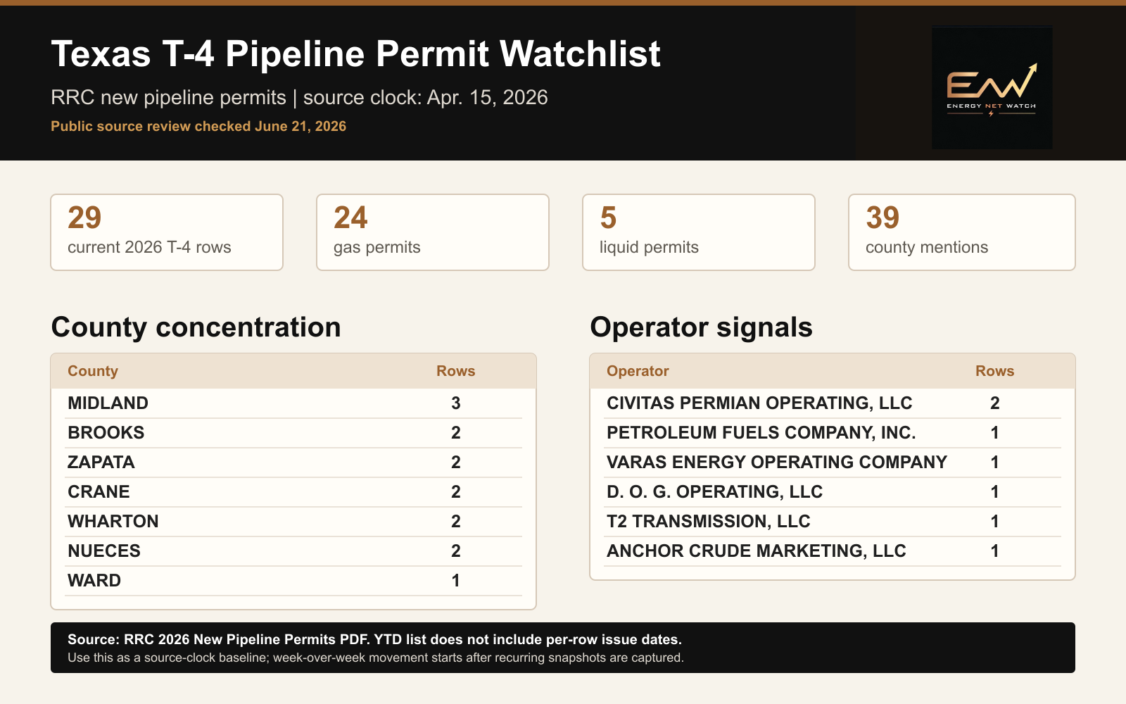
EnergyNetWatch public T-4 watchlist snapshot from the RRC 2026 New Pipeline Permits PDF. The graphic uses the current source-clock baseline and does not imply per-row issue dates that are not present in the YTD PDF.
The watchlist starts as a source-clock baseline. Once recurring snapshots are captured from later RRC updates, the same structure can show week-over-week movement, fast movers, emerging counties, and changes relative to a rolling 90-day baseline.
Why A Watchlist Is Better Than A One-Off Article
The evergreen T-4 explainer answers the searcher's first question: what a Texas RRC T-4 pipeline permit is, how GIS route evidence fits, and why a source row needs context.
The watchlist answers a different question: what the current source list shows and which records deserve review.
Those are separate jobs.
The explainer should stay stable. The watchlist should change as the source changes.
That gives EnergyNetWatch a cleaner public content system:
| Page type | Job |
|---|---|
| T-4 permit explainer | Explain the source, search process, GIS route evidence, and workflow |
| T-4 watchlist hub | Maintain the current baseline and archive recurring reviews |
| Dated T-4 source review | Highlight the current operator, county, commodity, and classification signals |
| LinkedIn/X signal | Pull one useful record or trend into a short public post |
This structure gives search users a stable answer and gives repeat readers a reason to come back when the source list changes.
What The Watchlist Tracks
The Texas T-4 watchlist is designed around public-record fields that can support a real business follow-up.
| Field | Why it matters |
|---|---|
| T-4 permit number | Gives the record a source identifier for review and lookup |
| Operator or applicant | Supports account screening and operator-level monitoring |
| P-5 number | Helps distinguish similar operator names |
| Commodity | Separates gas, liquid, and other pipeline context |
| Classification | Helps separate private, common-carrier, gas-utility, and other record types |
| County list | Shows where the infrastructure signal is located |
| Source clock | Prevents stale records from being presented as current activity |
| GIS route evidence | Adds spatial context when a route match is available |
The watchlist should not flatten those fields into one generic activity number. A gas/private row in Reeves County, a common-carrier liquid row across Culberson, Loving, and Winkler, and a gas-utility row across several counties can all be useful, but they do not mean the same thing.
Current County And Operator Signals
In the current 2026 public list, Midland appears three times. Brooks, Zapata, Crane, Wharton, and Nueces each appear twice.
| County | Current rows |
|---|---|
| Midland | 3 |
| Brooks | 2 |
| Zapata | 2 |
| Crane | 2 |
| Wharton | 2 |
| Nueces | 2 |
| Ward | 1 |
The operator view is more distributed. Civitas Permian Operating, LLC appears twice. Most other listed operators appear once in the current public baseline.
| Operator | Current rows |
|---|---|
| Civitas Permian Operating, LLC | 2 |
| Petroleum Fuels Company, Inc. | 1 |
| Varas Energy Operating Company | 1 |
| D. O. G. Operating, LLC | 1 |
| T2 Transmission, LLC | 1 |
| Anchor Crude Marketing, LLC | 1 |
This is where the watchlist becomes more useful than a static list. If a future RRC update adds new rows, EnergyNetWatch can separate the current additions from the baseline and show whether a county or operator is moving above its recent average.
Example Records Worth Reviewing
Three records in the current list show why a T-4 watchlist should be more than a count.
| Record | Why it is worth review |
|---|---|
| Enterprise Products Operating LLC in Martin and Midland counties | Large midstream operator, gas/private classification, and Midland Basin county context |
| Diamondback E&P LLC in Midland County | Operator-linked infrastructure context that can be read alongside drilling and well activity |
| Plains Pipeline L.P. in Culberson, Loving, and Winkler counties | Liquid/common-carrier row across core Delaware Basin counties |
None of those rows should be presented as a completed project by themselves. The next step is review: route match, permit detail, source documents, related wells, nearby drilling permits, facility records, and whether the record supports an account, project, or API workflow.
How Weekly Movement Should Be Scored
When new source snapshots are available, the watchlist should score the update with more context than a raw count.
| Metric | Use |
|---|---|
| This update | Number of new or changed rows in the latest source snapshot |
| Rolling 90-day average | Baseline that makes the current count meaningful |
| Fast movers | Operators with the largest increase in T-4 activity |
| Emerging counties | Counties moving above their recent baseline |
| Commodity mix | Gas, liquid, or other row share |
| Classification mix | Private, common carrier, gas utility, or other classifications |
| Route evidence | Which rows have confirmed or candidate GIS context |
A reader should be able to tell whether a source update is normal, concentrated, or worth immediate follow-up.
What The Watchlist Does Not Prove
The watchlist is intentionally conservative.
| Not proven by the watchlist alone | Why |
|---|---|
| In-service status | A listed T-4 permit row does not confirm active operation |
| Construction completion | Additional source review may be required |
| Final route certainty | GIS evidence must be matched and reviewed |
| Capacity or economics | T-4 permit rows do not provide a commercial valuation |
| Complete counterparty exposure | The public row does not identify every commercial relationship |
This caveat is not a weakness. It is the difference between a public-record lead and an unsupported claim.
Request The Current T-4 Route Evidence Table
The public watchlist shows enough to validate the workflow. The full EnergyNetWatch workflow is built for users who need the table, route evidence, operator grouping, county context, exports, alerts, or API access.
Request the current Texas T-4 route evidence table if your team wants the current T-4 table, route review, county/operator rollups, map context, exports, or API-ready infrastructure records.
Latest Watchlist Archive
- Texas T-4 Pipeline Permit Watchlist: June 2026 Source Review
- Texas RRC T-4 pipeline permits: map context to GIS route evidence
- Texas T-4 pipeline permits: how midstream infrastructure leads work
- Midstream infrastructure data
Frequently Asked Questions
Is the Texas T-4 watchlist a replacement for RRC search?
No. The RRC remains the source system. The EnergyNetWatch watchlist organizes public source records into operator, county, commodity, classification, source-clock, map, export, alert, and API workflows.
Why does the watchlist show a source clock?
The source clock prevents a public-record list from being mistaken for live operational activity. The current public review uses the RRC list last updated Apr. 15, 2026 and checked by EnergyNetWatch on June 21, 2026.
Can this be updated weekly?
Yes, when the RRC source page or related source records update. The first watchlist establishes the baseline. Future updates can compare new snapshots against the prior snapshot and rolling averages.
Does a T-4 permit mean a pipeline is operating?
No. A T-4 row is a pipeline permit record. It may support an infrastructure lead or route-evidence review, but it does not by itself prove in-service status, construction completion, economics, or final project scope.
Sources
Data notes
EnergyNetWatch reviewed the RRC 2026 New Pipeline Permits PDF linked from the official RRC new-permits page on June 21, 2026. The RRC list footer says it was last updated Apr. 15, 2026. The YTD PDF does not include per-row issue dates, so this public watchlist is a source-clock baseline rather than a week-over-week movement claim.
Recommended next reads
Texas T-4 Pipeline Permit Watchlist: June 2026 Source Review
June 2026 Texas T-4 pipeline permit source review with current RRC rows, operator signals, county concentration, and caveats.
Texas RRC T-4 Pipeline Permits: Map Context To GIS Route Evidence
See how Texas RRC T-4 pipeline permits connect to GIS route evidence, operator context, source dates, diameter, commodity, and review workflows.
Texas T-4 Pipeline Permits: How Midstream Infrastructure Leads Work
Texas T-4 pipeline permits can become midstream infrastructure leads when matched to route, operator, county, and source context.
Oil And Gas Infrastructure Records: Facility Evidence vs Lead Signals (2026)
EnergyNetWatch separates oil and gas infrastructure records by evidence basis: Texas facility permits, New Mexico leads, T-4 signals, and state-source leads.
Related EnergyNetWatch pages
Want the current table behind this analysis?
Public articles use selected examples. Request access if your team needs current source refreshes, exact identifiers, maps, exports, alerts, saved workflows, or API access for this market.