Reeves County Texas Drilling Activity: June 2026 Permit Signal
Reeves County Texas drilling activity review using the current June 2026 W-1 permit pull, operator signal, source-stage caveats, and EnergyNetWatch workflow context.
By Johnathan · Reviewed by EnergyNetWatch Research · Last updated 2026-06-22
Key Takeaways
- The current Texas permit table shows a latest issue date of June 19, 2026 and a latest load date of June 22, 2026.
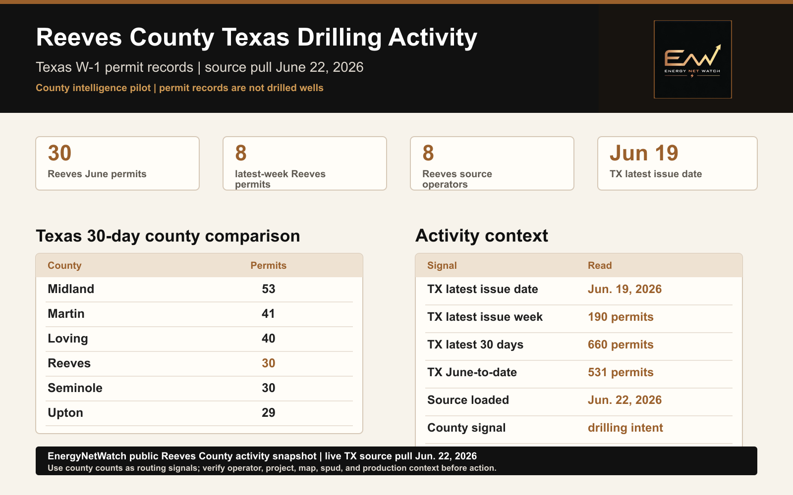
- Reeves County has 30 June W-1 permit records through June 19, with 8 records in the latest issue week and 8 source operators in the June window.
- The public county page treats permits as drilling-intent records and points serious users to the current county table, map, exports, alerts, and API workflow.
Reeves County is still a strong county-intelligence page, but the evidence should come from the current Texas permit feed, not from the older May packet.
The EnergyNetWatch live Texas permit table was refreshed from the weekly source path on June 22, 2026. The latest Texas W-1 permit issue date in the public review is June 19, 2026.
That changes the read.
The public question is not "what did Reeves do in May?"
The better buyer question is:
What does the current June permit window show in Reeves County, and how should a team route that signal into operator, project, map, spud, production, export, or alert work?
Reeves County Texas Drilling Activity Snapshot
In the current June review, Reeves County shows 30 Texas W-1 permit records from June 1 through June 19, 2026.
Reeves is not the largest Texas county in the latest 30-day permit window. Midland, Martin, and Loving currently rank ahead of it on the same reviewed basis. Reeves still belongs in the first county-intelligence group because it remains a core Delaware Basin activity county and has enough current operator/project signal to support a useful public page.
| Metric | Current public read |
|---|---|
| Reeves County June permits through June 19 | 30 |
| Reeves County latest-week permits | 8 |
| Reeves County source operators in June window | 8 |
| Texas latest permit issue date | June 19, 2026 |
| Texas permit table loaded | June 22, 2026 |
| Texas latest issue-week permits | 190 |
| Texas latest 30-day permits | 660 |
| Texas June-to-date permits | 531 |
EnergyNetWatch Reeves County public activity snapshot from the June 22 Texas source pull. Permit records are drilling-intent signals, not drilled wells.
That is a better public page than a stale month-end summary. It shows the current source clock, the county count, the statewide context, and the caveat.
A permit record is not a drilled well. A permit record is also not production. It is an early source-stage record that can tell a sales, service, land, midstream, or analyst team where activity may deserve review.
Why Reeves County Matters
Reeves is useful because it connects three buyer questions:
| Buyer question | Reeves County use |
|---|---|
| Is there current drilling-intent activity? | Yes. Reeves has 30 June W-1 permit records through June 19. |
| Is the activity concentrated enough to review? | Yes. Reeves has 8 latest-week permits and 8 source operators in the June window. |
| Is this a field-action signal by itself? | No. It needs operator, lease, field, map, spud, and production context before action. |
That last point matters. The county page should not pretend that a public permit count is the whole workflow. The public page should show the signal, explain the caveat, and point serious users toward the current table and map.
Current Reeves Operator Signal
The current Reeves County June window is led by a visible Anadarko E&P Onshore permit cluster, followed by Tarpon Resources, TRP Operating, UpCurve Energy, and several smaller source-label rows.
| Operator/source label | Reeves June permits | Public read |
|---|---|---|
| Anadarko E&P Onshore LLC | 12 | Wizard lease cluster in the Orla area; high enough to review as a project signal. |
| Tarpon Resources, LP | 4 | Jobe State records in the Toyah area; check lease/project grouping. |
| TRP Operating LLC | 4 | Benton records in the Mentone area; profile fields need source review. |
| UpCurve Energy, LLC | 3 | Eastern Pearce records in Wolfbone trend area; horizontal new-drill records visible. |
| Other source labels | 7 | Smaller rows that still need map/operator review before action. |
This is the type of table a public page can show without giving away the whole product. The count is useful. The workflow is more valuable.
Texas County Comparison
Reeves is part of a broader Texas county set in the current 30-day window.
| Rank | County | Latest 30-day permits | Public read |
|---|---|---|---|
| 1 | Midland | 53 | Current Midland Basin activity concentration. |
| 2 | Martin | 41 | Strong Permian follow-up county. |
| 3 | Loving | 40 | Core Delaware Basin county with current permit flow. |
| 4 | Reeves | 30 | Current Delaware Basin county signal with operator clusters. |
| 5 | Seminole | 30 | Needs source review because county/source labeling can require normalization. |
| 6 | Upton | 29 | Still active, but below the leading 30-day county set. |
This table is more useful than a statewide count because it gives the user a starting point.
If someone sells services, materials, infrastructure support, data, land work, or business development coverage into the Permian, the useful question is not "Texas had 660 permits in the latest 30-day window." The useful question is which counties, operators, and projects deserve attention first.
What Reeves County Does And Does Not Prove
The current Reeves County read proves that Reeves has current June W-1 permit activity in the live Texas permit table.
It does not prove the wells were drilled.
It does not prove completion timing.
It does not prove production impact.
It does not prove one operator drove the entire county signal.
That is why the full workflow matters. A serious Reeves County review should connect the county permit table to operator labels, leases, fields, purposes, profiles, filed dates, approved dates, depth where available, reported spuds, existing wells, production source clocks, map layers, and export or alert logic.
How A Buyer Should Use The Reeves County Signal
For business development teams, Reeves is a county-prioritization signal. It tells the team that Reeves belongs in the current Texas review list, but not above Midland, Martin, or Loving on permit count alone.
For oilfield service and supply teams, the next step is not a blog post. The next step is a county-filtered permit table, operator grouping, lease/project review, and map view.
For midstream and infrastructure teams, Reeves activity should be checked against nearby T-4, facility, pipeline, and project evidence where the records support that connection.
For analysts and data buyers, Reeves is a good example of why source stages should stay separated. Permits, spuds, production, infrastructure records, and maps are related, but they are not interchangeable.
Reeves County Follow-Up Workflow
The public page shows the county signal. The EnergyNetWatch workflow turns that signal into an operating process.
| Workflow step | What it answers |
|---|---|
| County permit table | Which Reeves County records are in the current source window? |
| Operator grouping | Which source operator labels appear in the county? |
| Field/project review | Which fields, leases, purposes, profiles, and depths are visible? |
| Reported-spud check | Which records have stronger drilling follow-through evidence? |
| Production source clock | What is the latest reported production month for context? |
| Map review | Where are the records located relative to wells, counties, and infrastructure? |
| Export, alert, or API | Should the county be monitored automatically? |
That is the product value. Public records show rows. EnergyNetWatch turns the rows into repeatable county and operator workflows.
Why This Becomes A Recurring Page Type
County activity pages can become one of the strongest public content lanes for EnergyNetWatch because each county naturally combines:
- permits
- operators
- wells
- production source clocks
- reported spuds
- maps
- infrastructure context
- watchlist updates
That is stronger than writing broad pages around "oil and gas data." Google and buyers both need proof that the site is authoritative on real oil and gas workflows. County pages provide that proof.
Reeves stays in the pilot group because the current data supports it. The same format should apply to Midland, Martin, Loving, Eddy, Lea, McKenzie, Grady, Converse, and other high-value counties where the source records pass QA.
Request The Current Reeves County Activity Table
The public page shows the county signal and the caveats. The app workflow is for users who need the current Reeves County source records, operator grouping, map context, exports, alerts, or API access.
Request the current Reeves County activity table if your team wants the current county permit table, operator rollup, map context, source-date review, exports, alerts, or API-ready records.
Frequently Asked Questions
Does 30 Reeves County permits mean 30 wells were drilled?
No. The 30 count is a permit-stage signal in the current June source window. It should not be described as drilled wells.
Why start with Reeves County if Midland currently has more permits?
Reeves is a high-intent Delaware Basin county with current operator/project signal. It is not the only county that deserves a page. Midland, Martin, and Loving should follow.
Why not publish every Texas county at once?
Because thin county pages would hurt quality. The better approach is to publish reviewed county pages where current permits, movement, source dates, and buyer relevance support a strong public read.
What should a buyer request?
Ask for the current Reeves County activity table. That is more specific than a generic demo request and maps directly to the workflow shown on this page.
Sources
- EnergyNetWatch live Texas
drilling_permitsread-only review run June 22, 2026 - Texas W-1 permit records with latest issue date June 19, 2026 and latest load date June 22, 2026
- Related state page: Texas Oil And Gas Permit Activity Watchlist
- Related article: Texas Operator Activity Roundup: May 2026
Data notes
EnergyNetWatch live Texas drilling_permits read-only review run June 22, 2026. The current Texas W-1 permit table latest issue date was June 19, 2026. Permit records are treated as source-stage drilling-intent signals, not drilled wells or production evidence.
Recommended next reads
Texas T-4 Pipeline Permit Watchlist: RRC Source Signals (2026)
Texas T-4 pipeline permit watchlist with RRC source clock, operators, counties, commodity mix, and route-evidence workflow context.
Texas Drilling Permits By Operator: May Permits, Reported Spuds, And Production (2026)
Texas drilling permits by operator for May 2026, with latest reported production and 2026 reported spud leaders from EnergyNetWatch.
Texas RRC Data Guide: Production, Permits, Well Records, And Source Dates (2026)
Texas RRC data guide for production, drilling permits, well records, source-date lag, and EnergyNetWatch workflows.
Oil And Gas Data Freshness: Why Permits, Spuds, And Production Dates Differ (2026)
Oil and gas data freshness guide explaining why permits, reported spuds, and production records have different source dates.
Related EnergyNetWatch pages
Want the current table behind this analysis?
Public articles use selected examples. Request access if your team needs current source refreshes, exact identifiers, maps, exports, alerts, saved workflows, or API access for this market.